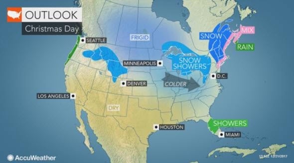
A White Christmas Limited To Upper Midwest & U.S. And Canada’s East Coast

There are no huge storms forecast, but rather areas of rain, ice and snow that will affect heavily populated areas and popular travel routes.
The first storm go from the upper Gulf coast to the lower Great Lakes, central and southern Appalachians and the Interstate 95 corridor of the Northeast with rain from Friday to Saturday. Snow, ice and treacherous travel conditions will spread from the central Great Lakes to part of the central Appalachians and New England into Saturday.
Another storm will blanket the Rockies, Plains and Upper Midwest with snow into Christmas Eve.
But the only places likely to have a white Christmas are the upper Midwest and along the New England coast into Canada. There is potential snow from the second storm in parts of the central Plains, Ohio Valley states and central Appalachians.
Accumulating snow is forecast in Omaha, Nebraska; Kansas City, Missouri; Des Moines, Iowa; St. Louis; Chicago; Indianapolis; Detroit; Cleveland and Toronto as it rolls out Saturday night and Christmas Eve. Snow may cover the ground in Evansville, Indiana; Louisville, Kentucky; and Cincinnati, Dayton and Columbus, Ohio.
At this time, all or mostly rain is forecast from Washington, D.C., to Philadelphia and Atlantic City, New Jersey.

If the two storms merge together and strengthen at a fast pace, then accumulating snow may fall as far to the southwest as Washington, D.C. Otherwise, this will happen on Christmas Day, bringing heavy snowfall to much of central and northwestern New England and northeastern New York state.
In California, where wildfires are still raging, the dry weather continues, creating risks for more fires and making for a long Christmas weekend for firefighters and homeowners.
A record 107.3 million people will be traveling from Saturday, Dec. 23, through Monday, Jan 1, according to the American Automobile Association (AAA).
For your individual Christmas weekend and day forecast, go to: AccuWeather.com
Leave a Reply
You must be logged in to post a comment.